Major road improvement schemes
On this page ...
England's Economic Heartland - Vauxhall Way
Hitchin Road/Stopsley Way/Vauxhall Way roundabout - upgrade works
England's Economic Heartland - Vauxhall Way
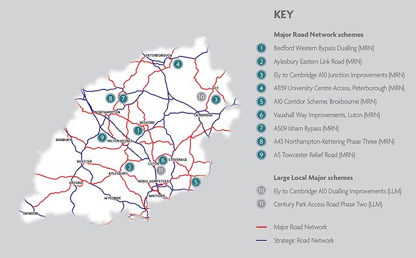
More than £700m worth of road investment priorities in and around the Oxford to Cambridge Arc, incorporating Luton, have been submitted to government by regional body England’s Economic Heartland (EEH).
The schemes, which include junction improvements, capacity upgrades and new relief roads, would reduce congestion and improve journey times.
In May 2019, EEHs partners submitted scheme proposals for consideration for the first five- year programme and following a review process, EEH is submitting 11 schemes to the Department for Transport as a key parts of the UK and regions Major Road Network (MRN).
One of the schemes identified and submitted is Vauxhall Way which is an important part of Luton’s strategic highway network.
Improvements to Vauxhall Way, which would also involve supporting sustainable transport policy to encourage cycling, walking and public transport, is also in line with our latest Local Plan
Some funding for junction improvements is currently available. However, the council’s aspiration is for a significant programme and this will include looking at options such turning the road into a dual carriageway to reduce congestion.
The project is still in development and there will be consultation as the scheme is developed and currently the focus in on securing funding for the project.
For more information on the programme and the other road schemes visit the England's Economics Heartland website.
The schemes are:
- dualling Bedford Western Bypass
- dualling Aylesbury Eastern Link Road
- dualling the A10, Ely to Cambridge
- junction improvements on the A10, Ely to Cambridge
- new junction at the A1139 University Centre, Peterborough
- junction improvements on the A10, Broxbourne
- new access road serving Century Park (phase two), Luton
- dualling A505, Vauxhall Way, Luton
- A509 Isham Bypass, Northamptonshire
- dualling A43 between Northampton and Kettering (phase three)
- A5 Towcester Relief Road
As the sub-national transport body for the region, England's Economic Heartland (EEN) is tasked with preparing the region’s advice to government in respect of investment priorities for the MRN, along with the large local major schemes.
Investment priorities for the first five year programme (2020-25) were submitted in July 2019.
The MRN is the country’s busiest and most economically important local authority ‘A’ roads. A specific new funding stream is dedicated to improvements on MRN roads. The MRN was classified following a government consultation in 2018.
In May 2019, EEHs partners submitted scheme proposals for consideration for the first five year programme. Following a review process, EEH is submitting 11 schemes to the Department for Transport.
Schemes being proposed are not ranked or in competition with each other, they have been reviewed on their own individual merits for inclusion in the regional programme.
They will be considered by the Department for Transport for a funding decision later this year.
Hitchin Road/Stopsley Way/Vauxhall Way roundabout - upgrade works
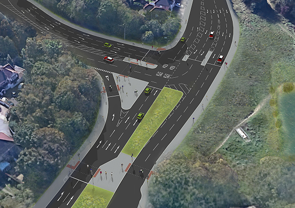
Following the recent public consultation and a decision from Luton Council’s Executive to approve the improvement works at the junction of Hitchin Road with Stopsley Way and Vauxhall Way, Volker Highways will be starting works on site week commencing 27 January 2020. The works are anticipated to last 7 months. How we have taken on board comments from the consultation is explained further in the FAQ's below.
The roads will be open throughout the majority of the works; however, any closures will be updated via the information signs on site.
The purpose of the works is to improve the safety and efficiency of the junction by converting the roundabout into a signalised junction.
The junction will be completely upgraded and improvements will include:
- new safety measures, including improved controlled Toucan crossings for pedestrians and cyclists;
- improved pathways for cyclists and pedestrians;
- improved LED street lighting and CCTV monitoring;
- additional tree planting on site and at Ashcroft Park to double the number of trees lost as a result of the scheme; and
- new sustainable drainage system and flood protection
After reviewing responses from the public consultation, it was highlighted that there is a desire to improve safety, traffic flow, pedestrian and cycling facilities.
However, it was also noted that there are concerns that a signalised junction would make traffic flow worse and increase pollution.
In order to demonstrate how Vauxhall Way will operate with the anticipated future growth comparing a scenario where we do not convert the roundabouts into signalised junctions, the council has developed movie clips which can be viewed below. The clips show, side by side how Vauxhall Way would operate with the existing road layout compared against the proposed road layout during the future morning peak and future afternoon peaks.
Downloads
Hitchin Road Stopsley Way MasterplanVauxhall Way Road Improvments
Due to future developments proposed for the East Luton area, the council commissioned an assessment of the cumulative impact these would have on the traffic network – see study and option appraisal below.
The report identified various roads and junctions that would operate over capacity and therefore would likely result in increased traffic, longer queue lengths and journey times. The council is currently investigating various proposals in order to minimise this.
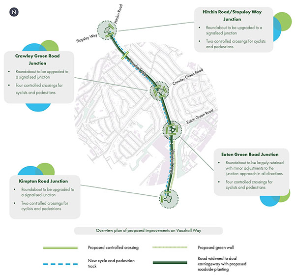
As part of this review, the council is progressing improvement options for the Vauxhall Way corridor. The proposals would also make this route safer for pedestrians and cyclists. See concepts designs below.
There are also a number of other benefits that this project can bring to the local community, including: sustainable drainage and flood risk reduction, increased aesthetics and biodiversity through additional planting and improved safety for all road users.
Proposed Improvements
Traffic modelling (which demonstrates how a highways junction or network will cope with specific levels of demand) suggests the current roundabout layouts will be operating over capacity in the coming years.
Based on the modelling, the proposal is to convert three of the four roundabouts (Kimpton Road, Crawley Green Road and Hitchin Road/Stopsley Way) to signalised junctions which will be designed to reduce traffic congestion.
The proposed junctions will not only assist with tackling congestion and reducing delays but also provide increased safety for all road users and prioritising more sustainable modes of transport.
Modelling suggests that the Eaton Green roundabout can be retained with minor adjustments required to the road layout.
The proposals aim to create a better environment for all road users, encouraging more people to travel by bicycle and on foot. We are suggesting new segregated cycle lanes and footpaths along Vauxhall Way with safer controlled crossing facilities for cyclists and pedestrians at the main junctions. The cycle route will connect with the following:
- Kimpton Road
- Parkway Station
- National Cycle Route 6
- Housing Development near Cockernhoe
- Turners Road North and South
- Active Luton Sports Village
Modelling identifies further benefits from the widening of Vauxhall Way. The additional capacity gained from the added lanes will help reduce queue lengths and allow greater flow of traffic to pass through the junctions.
The additional lanes also provide an opportunity at a later date to deliver a dedicated sustainable traffic lane i.e. bus or electric vehicle lane etc. The proposal is to provide a dual carriageway with two lanes in each direction and a central reservation along Vauxhall Way.
The proposal for Vauxhall Way aims to improve safety along the whole route. We are looking to enforce speed limits and provide separation between the directions of vehicle movement with a central reservation. We also aim to introduce safer crossings and street lighting for increased security at night.
The proposal is to remove footbridges and underpasses along Vauxhall Way in favour of controlled crossings.
The proposals for Vauxhall Way will aim to provide facilities along the corridor such as Variable Message Signs providing real time journey information to drivers, traffic and air monitoring units.
A green wall has been proposed adjacent to the southern section of Vauxhall Way, introducing a variety of interesting plant species. The proposals also include roadside planting of wild flowers and trees to mitigate the impact of potential tree removal and benefit the area aesthetically. This will encourage biodiversity as well as help to reduce noise and improve air quality.
We are also proposing sustainable drainage features which would contribute to a greener, more environmentally friendly way of managing storm water and flood risk.
Hitchin Road/Stopsley Way/Vauxhall Way
Following the recent public consultation and a decision from Luton Council’s Executive to approve the improvement works at the junction of Hitchin Road with Stopsley Way and Vauxhall Way, Volker Highways will be starting works on site week commencing 27 January 2020. The works are anticipated to last 7 months. To view more regarding the details of this junction improvement please visit the Hitchin Road/Stopsley Way/Vauxhall Way roundabout - upgrade works page.
FAQs
Vauxhall Way Corridor
The council proposes to mitigate noise and pollution through design via the choice of materials used when constructing the carriageway as well as strategic planting of trees to reduce noise and improve air quality. The proposed junctions and additional carriageway space along with the enforced speed limits will promote a steadier flow of traffic through the corridor reducing a build-up in traffic reducing the associated impact of noise and pollution.
It is perceived that roundabouts provide more capacity than signalised junctions. Traffic modelling (which demonstrates how a highways junction or network will cope with specific levels of demand) suggests that the current roundabout layouts will be operating over capacity in the coming years, resulting in increased delays on the network. Therefore mitigating works are required to tackle this. The council is proposing to install signalised junctions that have been designed to cater for the increased levels of traffic. Signalised junctions will also provide increased safety for all road users providing for cyclists and pedestrians as well as enabling the council to prioritise for more sustainable means of transport.
Junctions are not suitable for carrying out a ‘U-turn’ manoeuvres. It is advised that you plan your journeys in advance to ensure you are able to reach your destination safely. Each junction will be assessed individual with regards to traffic movements. If a genuine reason is required at any of the junctions, the council will investigate how to manage this situation on a case by case basis. If you feel that at any of the proposed junctions will restrict your current journey, please notify us and provide details via the consultation exercise.
Vauxhall Way concept designs
- Concept design 1
- Concept design 2
- Concept design 3
- Concept design 4
- Concept design 5
- Concept design 6
- Concept design 7
- Concept design 8
- Concept design 9
- Concept design 10
- Concept design 11
- Concept design 12
- Concept design 13